|
| |
Patagonia special
(Download/print in pdf-format)
|

|
The WorldWideTrails went with their backpacks filled with hiking gear and photo
equipment to one of the most untouched areas of the world. The south as you
can get to the mainland, Patagonia! This unspoiled southern part of Chile and
Argentina is dotted with vulcanos, glaciers and phantasy shaped mountains.
Indian names like Huerquehue mixes with spanish labels like Torres del paine.
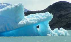
The blue icebergs floating in glaciermilk filled lakes appeals to everyone that
loves the out door.
|
The Andes Mountains
The Andes Mountains also known as the Cordillera de los Andes are the longest
chain of mountains stretching along the entire west coast of South America from
Cape Horn to Panama and Venezuela for a distance of 4,500 miles (7,200 kilometers).
The latitude is 10° N. to 57° S. The longitude is 70° W. to 80° E.
This second highest Mountain Range (Only the Himalaya of northern India and Tibet
are higher ) have many peaks rise over 20,000 feet. The chain is about 400 miles
(645 kilometers) wide across its widest part. According to the Quechua word 'anti'
the Andes means 'copper'. Rich in mineral resources the Andes is said to be one of
the most valuable mountain ranges in the world.
A geologically young system, the Andes were originally uplifted in the Cretaceous
and Tertiary periods. They are still rising; volcanoes and earthquakes are common.
The folded ranges are discontinuous merging and bifurcating within the system but
as a whole they form one of the world's most important mountain masses.
The Andes may be broadly divided into three regional zones: the Northern Andes,
which includes the mountains that run through Colombia, Venezuela, Ecuador, and parts
of northern Peru; the Central Andes, which includes the part of the range that runs
through Bolivia, the rest of Peru, northern Argentina, and Chile; and the Southern Andes,
which includes the mountains that run through southern Chile and Argentina, through
Patagonia, and down to the southernmost tip of South America, Tierra del Fuego. In this
special we will focus on the southern region of the Andes: The Patagonian Andes.
|
|
Glaciers
Ice sheets and glaciers form the largest component of perennial ice on Earth.
Over 75% of the world's fresh water is presently locked up in these frozen
reservoirs. A Glacier is any large mass of perennial ice that originates on
land by the recrystallization of snow or other forms of solid precipitation and
that shows evidence of past or present flow. A glacier occupying an extensive
tract of relatively level land and exhibiting flow from the center outward is
commonly called an ice sheet. Glaciers form when snow accumulates on a patch
of land over tens to hundreds of years. The snow eventually becomes so thick
that it collapses under its own weight and forms dense glacial ice. When enough
of the ice is compacted together it succumbs to gravity and begins to flow downhill
or spread out across flat lands. What makes glaciers unique is their ability to move.
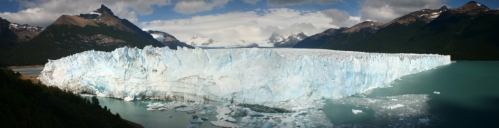
Due to sheer mass, glaciers flow like very slow rivers. In southern Argentina, near
Calafate the Parque Nacional Los Glaciares we were able to visit several glaciars
like Spegazzini, Upsala and Perito Moreno.
Specially the beauty of Perito Moreno on a sunny day was beyond imagination.
See video ( 4 MB)
Hiking
Only a few destinations can match Argentina's and Chili′s magnificent settings and
regional splendor. Many regions in this part of the world offer treks that last anywhere
from half a day to a number of weeks.
You can hike through central Andes and lake district with volcanoes and primeval
forests of Araucaria, Alerce and other trees, to the glacier valleys and mountains of the
Torres del Paine and the National parks in the south.
Usually a professional guide takes a group of trekkers or hikers on the adventure while
cooks and other personal prepare food and take care of all the necessities. Many trekking
tours stay overnight in beautiful and desolate parts where camping is the most common form
of lodging. Other tours stay at small inns and hotels on the way. But also you can easily
trek on your own since most routes are well defined (at least in the summerseason).
In Pucon (Chili) we went up the volcano Villarrica with a guided tour, which is mandatory
unless you can proof to be an experienced alpinist. The advantage of such a guided tour is
also that the equipment and even thick waterproof clothes are provided. This clothes turned
out to be very useful since the way down you do on your but ! Yes your but. It is one of
the most wonderful experiences during our stay in Patagonia. Sitting down in the snow and
slide downhill while breaking with your ice pick and boots.

In Torres del Paine I went to the French valley starting with sailing the lake Pehoé to
refuge Paine Grande and pick up the trail there to camp Italiano. From there take the
direction to camp Brittania. Half way Brittania you have a beautiful view on the hanging
glacier Glaciar del Francés. (in and out 18 km).
In the lake district of Chili we hiked in to Huerquehue to the lago Verde.
Vulcanos
More than 30 spectacular volcanoes occur in the Andes Mountain range. At 19,347 feet,
Cotapaxi Volcano is the highest active volcano in the world. Some of the other
volcanic peaks include Cayambe (18,991 feet), Imbabura (15,117 feet), Pichincha (15,724 feet),
Chimborazo (20,697 feet) and Sangay (17,154), also one of the most active in the Andes. We
visited the Villarrica and climbed this active vulcano. On a
blue sky day we started at the cable station. Using crampons we walked the 1400m ascent
mostly through snow. Only the last part whre we walked on lavarocks we could do without the
crampons. Once at the top we had a spectaculous view on the suroundings but even mor exciting
was the crater. The red hot lava was jumping high every minute up to levels of 10 meters releasing
the gases.
See video ( 769 kB)

|
Cruce del Lagos
We traveled back to argentina across the Andes by bus and boat using what is known as
the Cruce de Lagos.
Cruce del lagos starts at Puerto Varas, known as "the city of flowers". From here the journey
continues towards Petrohué, bordering Llanquihue Lake. Here you can observe the impressive
Osorno and Calbuco Volcanoes, the dominating attraction of the entire landscape. From Petrohué
the boat/bus travel continues towards Bariloche in Argentina. Bariloche is sinonimous to lakes
and mountains. It is a traditional tourist destination with all services and within the most wonderful landscapes.
Bariloche has become one of the main cities in Patagonia. However, for those of
us who come from big cities, it still preserves the idiosyncrasy of a mountaineer′s town.
You can still bread clean air in its streets and the Nahuel Huapi Lake shows its
magnificence from every point in town. Walking down the wood′s footpaths still gives
the opportunity to be alone with oneself and in harmony with nature, far from the stress
and pollution of the big cities. see video ( 1256 kB)
Penguins

From Puntas Arenas we visited the island ″Isla Magdalena″, a natural monument because of
the presence of a hughe colony of penguins. This island is a preserve with only a lighthouse
and a jetty for the boat to land. It is amazing how you can walk between this little
stnd up creatures. Penguins are superbly adapted to an aquatic life. Their wings have
become flippers, useless for flight in the air. In the water, however, penguins are
astonishingly agile. Within the smooth plumage a layer of air is preserved, ensuring
buoyancy. The air layer also helps insulate the birds in cold waters. The plumage of
penguins in tropical and temperate zones is much thinner than that of more southern species.
On land, penguins use their tails and wings to maintain balance for their upright standing.
All penguins have a white underside and a dark (mostly black) upperside. This is for
camouflage. A predator looking up from below (such as an orca or a leopard seal)
has difficulty distinguishing between a white penguin belly and the reflective water
surface. The dark plumage on their backs camouflages them from above.
Diving penguins reach 6 to 12 km/h, though there are reports of velocities of 27 km/h
(which are probably realistic in the case of startled flight). The small penguins do not
usually dive deep; they catch their prey near the surface in dives that normally last
only one or two minutes. Larger penguins can dive deep in case of need.

Penguins either waddle on their feet or slide on their bellies across the snow,
a movement called ″tobogganing″, which allows them to conserve energy and move relatively
fast at the same time.
Penguins have an excellent sense of hearing. Their eyes are adapted for underwater
vision, and are their primary means of locating prey and avoiding predators; in air,
conversely, they are nearsighted. Their sense of smell has not been researched so far.
They are able to drink salt water safely because their supraorbital gland filters excess
salt from the bloodstream. The salt is excreted in a concentrated fluid from the nasal passages.
Climate - when to visit
The climate is not the same throughout the Andes because there are places
nearer to the equator than others. In the northern region, it is hotter
because it is closest to the equator. There are rain forests in this region,
due to the more humid, rainy climate. In the southern region, the mountains
are nearer to the Antarctic and it is much colder. It is not very populated
in the southern area.In the central region of this biome, the weather is
more mild because it is not near either the equator or the cold Antarctic.
Trekking is only possible for a maximum of 6 months starting in early november
and ending late april. The local holiday season January-February you may want
to avoid. If that's not possible make sure that you have your reservtions for
accomodation and local transport in time. On the other hand certain services
may be less availble outside the hoiliday season.
|
|
|

/218F26GZFTL__SL125_.jpg)