|
| |
Chapada Diamantina
(Download/print in pdf-format)

|
The WorldWideTrails took a short break in July, but off cause not without their hiking stuff and went to Brazil.
Diamonds were there goal and diamonds they found. Precious little spots on this earth that has amazing sights.
Some 450 km west of Salvador in the center of the state of Bahia is a beautiful colonial town called Lençois,
which is the gateway to the National Park Chapada Diamantina (Diamond Highlands). This ancient diamond trader’s
center in the middle of the Sertão served as base camp to explore the gems of the region.
|
The Diamond Highlands
Chapada Diamantina (pronounced as cha-pah-dah dee-ah-mon-tee-nah) could be translated as Diamond Highlands and is the
northern extension of the larger Espinhaço
mountain system, which starts in Minas Gerais state. This mountain range separate the smaller coastal river systems
from the large São Francisco River Valley that drains a good part of the interior of Brazil. The geographic coordinates
of the park are approximately 41º 20’ - 41º 35’ West longitude and 12º 20’ - 13º 25’ South Latitude. The altitude of
the park varies between 400 meters (1300ft) and 1700 meters (5600 ft) above sea level.
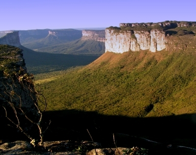
The park was established in 1985 and consists of table mountains and swampy valleys, forests and highlands
dotted with beautiful waterfalls and magic caves with blue water and swimming holes. It covers about 152.000 hectares
(600 square miles) and has a geo typical structure comparable to “Monument Valley”, a highland from origin but due to
erosion transferred in a table mountain landscape giving the mark to the area. Although the whole area is known as
“Chapada Diamantina” this article mainly refers to the national park since this is the most scenic part and is
devoted to hiking. The infrastructure of the trails is very old starting in 1700 when there was the 1st gold rush.
The gold mining lasted some 200 years. In 1844 the diamond period started and more and more settlements appeared in
the region connected with trails.
|

|
Lençóis
In 1844 when vast diamond deposits were discovered in the Lençois River it attracted miners and traders
who did business directly with French, English and German merchants. All these cultures are still reflected
in the buildings architecture making the city a colorful open-air museum. The Mercado Municipal, next to the
bridge over the Rio Lençóis that runs through the center, is where most of the diamonds were sold. It has
Italian and French style trimmings tacked on to make the buyers feel at home. The center of the town, between
two lovely squares is made up from cobbled stone streets, lined with two story nineteenth-century houses with
arched windows. The city flourished until 1871, but then declined due to the discovery of diamonds in South Africa.
The city of Lençois was declared (as is Mucugé and Igatú in the region) a National Heritage Site in 1973 by the
Brazilian Institute of Historic and Arthistic Heritage (IPHAN), due to it’s key role in the history of the area and
the interesting architectural styles preserved in their original buildings.
|

|
Hiking
The 1st thing you should do arriving in Lençois (or if you can before) is getting a copy of
the book of Roy Funch – “A visitor’s guide to the Chapada Diamantina Mountains”. The book is
a source for almost all you would like to know about Chapada Diamantina, the history, the nature,
the trails and more. In Lençois some hotel receptions sell it and also the bookstore Dois Irmãos
on the connection of the Plaça dos Nâgos and Plaça Horácio de Matos.
 The park offers over 40 organized trips (trekking or driving) through the park to
get acquainted with the tropical vegetation, the river system and the lakes, pools and waterfalls,
the Orchids and Bromeliad’s. Hikes are easy to arrange from Lençois either in groups by outdoor companies
or by hiring a guide (through the reception of your hotel). For sure there are hikes you can make on your
own but in most cases it is safer to hire a guide. Paths are not always well maintained and signs not always
clear. Guides are not expensive and as live is not easy around here it might help someone out.
Many of the trails you will find described in Roy Funch’s book and also you can find a map with the trails in the Dois
Irmãos. In the trail section Brazil you will find 2 hikes with GSP files and pictures: Cachoera Fumaça
(The Fumaça waterfall 10 km) and Pai Inácio – Lençois (14 km).
The way to get here
The best way to get there is to fly to Salvador (Bahia). From there you have 2 options: Go by bus or by car.
Bus leaves two times a day Salvador bus station (morning and night) and will take you to Lençois in about 6-7 hours.
When you have the budget rent a car. Leave Salvador to the highway BR324 (direction of Feira de Santana).
Some 5 km after Feira de Santana turn right on the BA-052 (direction Ipirá, Morro do Chappéu and Irecê). When you
arrive at Ipirá turn left to direction of Itaberaba (BA-130) until you reach the BR242. Go right and continue until
the sign to the left says Lençois. Total 435 km more or less 5 hours drive.

The place to stay here
Lençois is probably the nicest place to stay as base camp for your expeditions. The town is a colonial gem
and offers a wide range of Pousades, shops and restaurants. You can find also a lot of outdoor companies here
that offer a pallet of activities, transports and guides. Dois Irmãos is a well-equipped book & map shop just
around the right corner from the entrance of town. If you can afford it the pousada Cantos do Aqua offers a
very scenic setting and a marvelous kitchen. It is located almost next to the bridge that gives entrance to Lençois.
|
Poço's & Caves
One of the most astonishing things I encountered ever in my life was the visit to the Poço’s:
the Poço Encantado (Enchanted pool) and the Poço Azul. Although not really in the park and a bit
difficult to get there I will give it a place in this article, because when you visit here in the
right time and you are able to bridge the 150 km gap with Lençois on a sunny day you should go
there (unless it is Brazilian Holliday). Both caves care situated in the neighborhood of the BA-142.
Go from Lençois to the BR-242 and take right for some 35 km direction of Salvador. The go right
and head for Andaraí. Continue to Mucugé and halfway take left (east) to Itaité. This is a once paved
road and takes about another 19 km to the entrance road of the Enchanted Pool. You might want to use
the GPS file in the Points-Of-Interest section on the website or better hire a guide. If you speak
Portuguese or want to practice ask for Manoel França

The water in the underground pools is perfectly transparent due to the slow movement of the water.
At first sight it is difficult to see where the walls of the cave meets the water. Huge boulders and
fallen trunks at the bottom of the pool stand out clearly even though under as much as tens of meters
of water. But the magic is really seen when it is directly illuminated through a natural window in the
cavern wall and sunlight penetrates into the water in a cylinder of glowing blue beauty. The best month
to see this amazing phenomenon is June and July between the hours of 11:00 and 12:00.
The pool was formed in an area of limestone rock very susceptible to erosion by running water. Although
it still linked to the underground river system, the circulation is very slow consequently keeping the pool
crystal clear. The Poço Azul is a bit like the enchanted pool although more modest. The big advantage
however is that you are allowed to swim. July/August is here the best time to see the light.
Directly in the neighborhood is the Gruta Lapa do Bode where the guide Sinaldo together with his son
excavated this cave and now you can easily walk between stalactites and layers of over millions of years old.
The time to come here
The rainy season normally starts in November and precipitation rates stay high into February and March
although no monsoon rains (the climate is semi-tropical. Rainfall then diminishes gradually towards mid-year
and there is usually a short dry season (August until October). Because of this rain the area has abundant vegetation,
with a lot of flowers blooming in July. Most of the Chapada is about 1000 m above sea level. The tropical sun burns
brightly and a hat, sunscreen and a long sleeved shirt are very useful on long hikes.
Although trekking can be done all year around in summertime (November to March) it can be very hot and moisture.
The wintertime is most suitable for visits (July/August) since the chances are that it is quite dry and many of
the caves have the spectacular light entering and giving the marvelous blue shine. Certain services may be less
available outside the holiday season
|

|
|